
| Weather |
If a weather link becomes outdated please email Rick Heninger and/or Craig Goudie |
|---|
Weather Info |
|---|
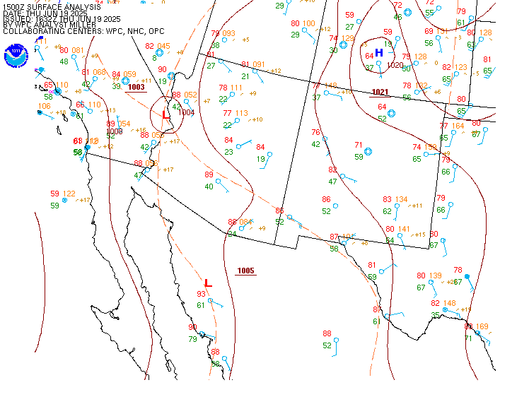
Surface MapsSurface maps tell you where the fronts are, and show you the atmospheric pressure distribution in the region. Good for figuring out if you have to call in sick, or just leave work early when a front's about to hit. |
|---|

|

|
|---|---|
National Surface Map Next 3 Days
|
Current Regional Surface Map
|
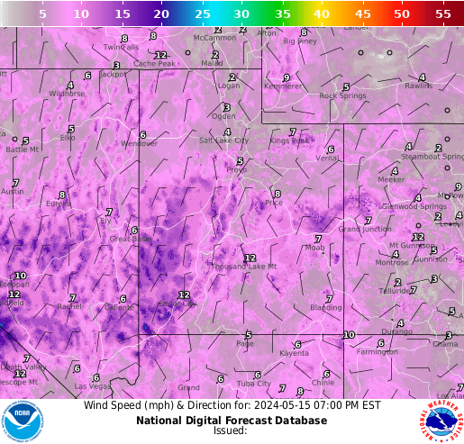
Winds |
Jet Stream |
|---|
|

|
|---|---|
Current Winds |
Jet Stream Forecast |
|
If the jet stream is over us with any speed, it greatly influences the sailing. This holds true unless we have dreaded "afternoon thunderstorms" in the area. Northerly or northwesterly jets will mean better sailing at Utah Lake. Westerly jet stream generally means good sailing at Sulfur Creek, and DeerCreek.
|
|
US Jet Stream from TWC US Jet from SFSU & Accuview |
More Generic Utah Weather |
|---|
|
|
Precipitation
Current Precipitation
|
|---|---|---|
Water Site Specific Weather InfoClickable Regional Mesonet Wind Map (very handy)
|
|---|
Rush
|
Grantsville
Reservoir
Reporting station right at the lake, what you see is what you get.
Grantsville seems to offer rides throughout the summer if you are an early bird.
Grantsville Forecast & Current Conditions
|
|---|
Utah Lake (PBH live webcam Lindon live webcam)The Provo Muni Airport reads pretty true to North wind speeds at Lindon. South readings are pretty consistent if the wind is Southwest. If the wind is Southeast, don't go to Utah lake. The Saratoga Springs site is not far from the city park and should be good for checking weather at the park (Just a couple of miles South of Rocky Point). The Springville (SSB) site is becoming popular with Kite Boarders as a qualifier for wind at the South Sandy Beach. The Bluffdale site appears to switch North about 2 hours before the North gets to SSB. ULSSB Forecast & Current Conditions UL Lincoln Beach Current Conditions Provo Boat Harbor Forecast & Current Conditions Lindon Launch Forecast & Current Conditions Saratoga Springs Forecast& Current Conditions MM19 Current Forecast & Current Conditions
|
Deer Creek (DC live webcam)The Charleston station is just North of lake, but about 20 feet off the ground. Charleston is currently the best indicator of wind on the lake, and is pretty consistent with what you'd be sailing. The Dam Chute is very consistent with what you'd be sailing at Sailboat Beach, but it's typically only up in the late fall and early spring. The Arrowhead reporting station is at 8,252 feet is a good predictor of planable winds from the Southwest later that day at DeerCreek (the "Pine" effect). DC Sailboat Beach Forecast & Current Conditions DC Island Beach Forecast & Current Conditions DC Snake Creek Launch Forecast and Current Conditions Deer Creek (Heber Airport near Charleston) DC Weather Talker 435-657-0817
|
|
|---|---|---|
Sulfur CreekThe First Divide station is the best bet. Wahsatch EB may be a good predictor for West wind at Sulphur. |
Salt PondsCourtesy Mike Rosberg: Anywhere between mile post 91 and 92, on I 80. I don't know if its really legal to park or not. Just flip your hood up before you go out. South only works if we have some strong south. The North Thermal is strong. The Bermester link is right on the west end of the ponds. The north thermal is not as strong as Rush since we don't have any venturi effect
|
|
YubaMorning Thermals in the 6.5 to 8.5 range under a South or Southwesterly flow.
|
MonaSouth wind potential much like Rush. Look for local South conditions at 15-25 before you go. The "Nephi" link is about 7 miles from Mona.
|
|
Willard Bay (Willard live webcam)
|
Jordanelle (Jnell live webcam)
|
|
Pineview (Pineview live webcam)Of dubious value, the Huntsville weather stations may be useful if the wind hits double digits. |
Bear Lake (Bl Live webcam)
|
Lake Mojave - "Winter Camp"
The Bullhead City report is fairly accurate with North wind on the lake at Katherine's. South wind is fairly accurate at 6 Mile Cove to the Searchlight reading. |
|---|
Kathrines Landing (South Mojave)
Lake Mojave (Bullhead City Airport) This windgauge is the closest to Kathrine's Landing.
NOAA Cabinsite Point Forecast The NOAA point forecast seems to be shortranged - accurate for the next two or three days. Check out the 10 day Weather Channel forecast for a long range forecast. Weather Channel Weather Channel 10 day forecast.
6 Mile Cove (North Mojave)
Lake Mojave Iwindsurf Forecasts
| 
Current Southwest Surface Map-Click for more clarity |
|---|
SnowKite Specific Weather Sites |
|---|
|
| ||
|---|---|---|
| National Animated Surface map for next 3 days | ||
|
Kenny's useful Winter Wind Links |
Powder MountainPowder Montain Ski Resort allows snow kiting up on top... Pay attention to all rules that Powder Mountain has on kiting their area. Ask on the forum if you need to get educated before going to Powder Mountain for your first time... CLICK HERE for a forum discussion from Jan 2011 about "PowMow". Also see the threads immediately surrounding it.
|
|
Park City (Home Depot)Driving east on I-80 drive an exit past Park City to exit at 40. Exit Silver Summit. Drive past Home Depot. Please respect the property, fences, etc. Use all kiting safety knowledge so that we are able to protect these kiting sites... Please respect the signs...
|
Rush LakeLake effect Snow and Wind from the GSL can bring powered riding. Wind pours from the North & South, with steady wind starting around 10 mph. In Jan, 2011, the snowpack in the Tooele valley was 200% normal... Haven't seen too many posts of people riding here yet.
|
|
Skyline DriveSkyline Drive in Fairview Utah discovered for Snowkiting by Brian and Heather Schenck. It has become the annual site of the Snow Kite Masters in the spring that is a great event to attend. Some argue that it has the best terrain for snowkiting in the world... Try it for yourself... |
Strawberry Reservoir AreaAll around strawberry Reservoir there are numerous areas to snowkite. Pay attention to all signs and powerlines... CLICK HERE for a very imformative thread in the forum with contribution from veteran experience.
|
|
|
|
Copyright 2019, Utah Windriders Association |
|---|